
Sam, Ross & Karen took all these pics - on a recent weekend trip to Fair Isle. I was fortunate to spend almost 3 years on the island working at the Fair Isle Bird Observatory & Lodge during the 1980's. I have hundreds of pictures from then but these are pictures from 2010.
Sumburgh Head & Lighthouse from the Fair Isle boat the 'Good Shepherd'. The journey time from the Grutness Pier at Sumburgh is around 2.5 to 3 hours & runs on Tuesday & Saturdays weather permitting. The boat also goes to Hay's Dock at Lerwick during the summer months on alternate Thursdays - that takes around 4.5 to 5 hours.


Fair Isle - Sheep Rock on the left, Ward Hill (the highest point on the right) with the TV, Radio & Mobile phone mast near the top. The white structure below the mast is the north lighthouse.

Sheep Rock, viewed from the north Harbour where the ferry docks. Sheep were kept on there for grazing until 1977. A boat journey is required to access the base of the rock (in the centre geo visible), and a chain was installed for a vertical climb to the top, around the centre of the rock. I climbed the chain three times in the 1980's & also got dropped off on the top via helicopter once - which was a lot nicer than climbing it.

The north lighthouse viewed from the ferry entering the north Harbour. The foghorn is visible on the promontory 'Da Niz'.

The north lighthouse. The accomodation block (left) was demolished in the mid-1980's when the light became fully automatic - a bank of photoelectric cells now occupies the site.


A handrail path was oroginally constructed out to the foghorn on the promnotory 'Da Niz'. This is now in some disrepair and the lowest point on the path shows signs of subsidence.

The newly constructed Fair Isle Lodge & Bird Observatory, just up from the north Harbour. A very nice building & although its not quite finished it is open for visitors.


The small headland of Landberg is just across from the Observatory. It is a scheduled monument as it is the site of a promontory fort. The outline of the building is still visible and the substantial undulating ramparts are also still visible. Excavations on Landberg have revealed the domestic setting of a house which had amongst it's finds whale bone tools for weaving and middle to late Iron Age pottery (100BC to 500AD).


The remains of a crashed second world war Heinkel are still visible just east of the airstrip at the base of Gilsetter. This information board tells the story.


The Fair Isle airstrip (centre), looking at Ward Hill, the highest point on the island, and the communications mast. A dirt track provides access to the mast.


There are some old wartime buildings, long disused, near the top of Ward Hill. These were part of a WW2 radar station.

There are also old small cable haul guauge railway tracks serving these old buildings which head to the top of Ward Hill.


A dry stone dyke, the 'feely dyke', divides the more fertile south end of the island from the rougher common grazing of the north end.

There are also old wartime buildings incorporated into the feely dyke, complete with what remains of old gun emplacements.


When the Bird Observatory was formed in 1948, several 'Heligoland' traps were constructed along the dry stone dykes and gulleys near to the observatory, and these remain in use to this day. These are used for catching birds for ringing. This is the 'Double Dyke' trap, the white line running alongside is the observatorys new water supply pipeline which has yet to be buried.

The Gully trap. The end of this gully is completely covered and funnels everything into the catching box.

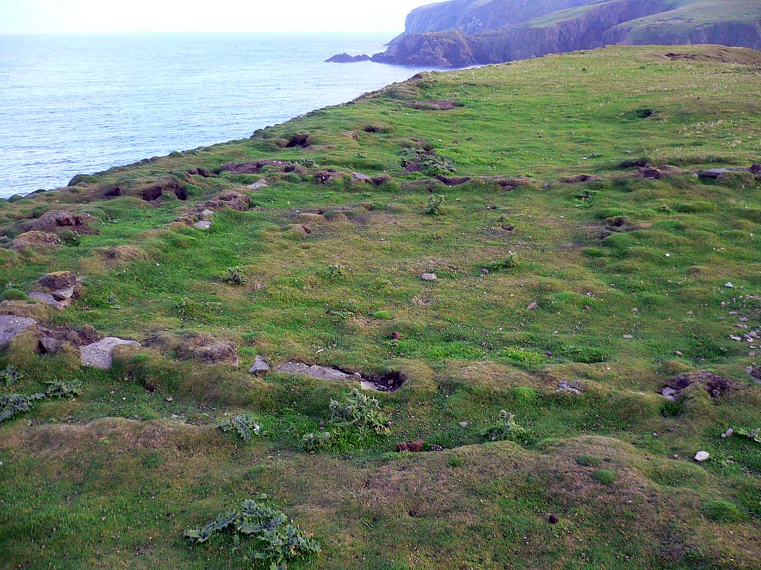
Also at this site are the remains of several water mills. Up to 9 mills were once in use here but fell into disrepair during the first world war. Some of the mill stones are visible in the top of the picture.

The more fertile south end of Fair Isle. All the crofts (and 2 aerogenerators) are in the south end of the isle. The aerogenrator to the left was the first commercial aerogenerator in the UK and was commissioned in 1982.


Near the south light are several boat 'noosts', above the beach at Kirkigeo. Fair Isle was once an important area for 'Haaf Fishing' and vast quantities of Halibut and other deep sea fish were caught and landed on the isle from the early 18th century until the decline of the fishery around the mid 18th century.


This building is in the background of the first boat noost picture. It is called the 'Puff Inn' and provides basic self-catering accomodation.


The south lighthouse is also fully automatic now and was the last manned lighthouse in Scotland. This picture was taken from 'Malcolms Head', just west of the lighthouse.

The old lighthouse buildings have now been converted to visitor accomodation.


The west cliffs of Fair Isle, seen from the top of Malcolms Head.

For more information about Fair Isle see:


.jpg)


looking forward even more to getting there now...
ReplyDeleteHello,
ReplyDeleteWonderful photos!
Have you heard of "Blue Lightning", a detective story by Ann Cleeves taking place in Fair Isle ?
I am currently translating it into French and really enjoy your views of Fair Isle and their comments. They are a great help for me.
I came across your blog through "double dyke trap", a phrase which puzzled me! Now I've seen what it is!
Thank you!